


Announcing CARTO BigQuery Tiler General Availability
We are excited to announce the general availability of CARTO BigQuery Tiler, a unique solution for visualizing massive spatial datasets hosted in Google BigQuery
We are excited to announce the general availability of CARTO BigQuery Tiler, a unique solution for visualizing massive spatial datasets hosted in Google BigQuery

Read how to improve retail trade area accuracy by moving beyond buffers & drive times to using spatial analysis & human mobility data

Geography is changing faster than ever before. Read our predictions for the key Spatial Data Science trends & industries to watch in 2021.

As many parts of the world enter into recession following the Coronavirus pandemic, read how Spatial Data Science can help identify areas with a greater risk
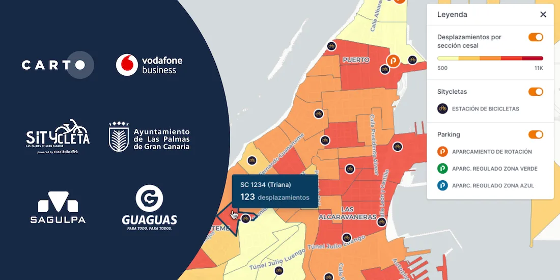
Optimizing transport infrastructure spatially is key to the future of mobility - see how CARTO, Vodafone, & SAGULPA built a platform for the city of Las Palmas
Learn how to import Waze for Cities traffic big data into CARTO using our Google BigQuery Connector for easy analysis & visualization in our step by step guide

We are very pleased to announce the formation of the CARTO Scientific Committee, and its inaugural members, to further advance the field of Spatial Data Science

With Mapbox announcing a change in their licensing this week, we share our thoughts on this news, basemap neutrality, & the future of spatial app development

Explore Avison Young's UK Cities Recovery Index, monitoring commercial real estate rebound post-pandemic, analyzing diverse sectors, and predicting recovery trajectories.

Import millions of records from a Snowflake database using our new connector & create insightful visualizations. How to combine Snowflake data warehouse & CARTO