Blogs
Use cases

How to Analyze Google BigQuery Data in CARTO

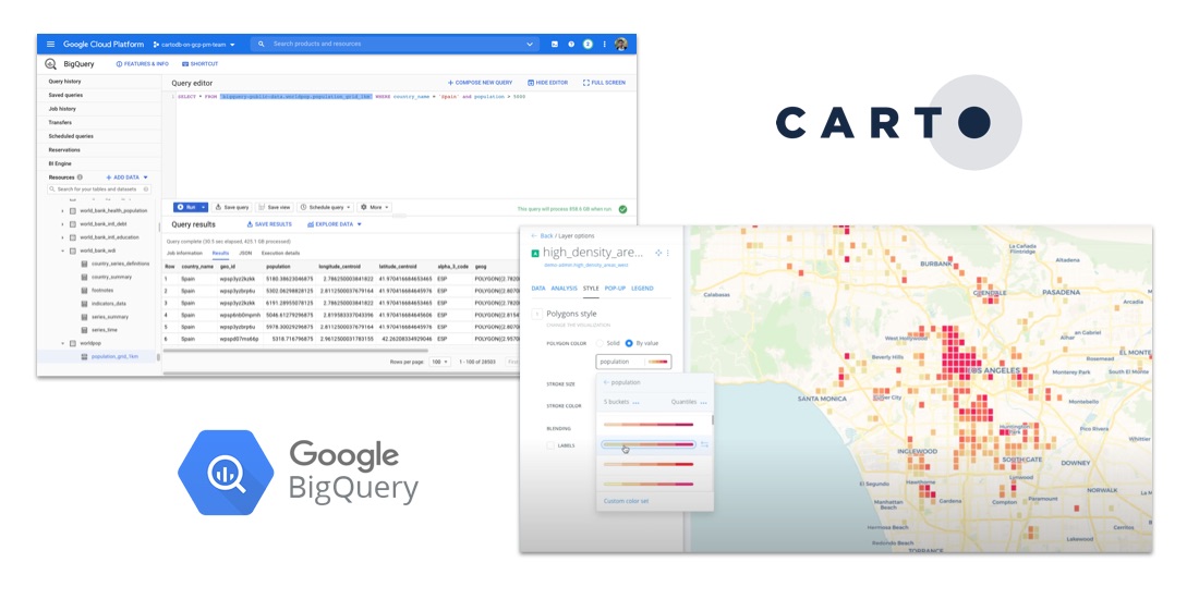
Learn how to visualize geospatial Big Data hosted in Google BigQuery by creating a CARTO instance on the Google Cloud Platform & using our BigQuery Connector.

CARTO ·
Blogs
App Development

CARTO for deck.gl: The Best Way to Develop Spatial Apps

CARTO is now available as part of the deck.gl framework & becomes our preferred & recommended library for building spatial applications

CARTO ·
Blogs
Use cases

Indoor Mapping & Airport Routing launched by Aena & Telefonica

Aena, in collaboration with CARTO, Telefónica, & Situm has launched 'AenaMaps', a solution leveraging indoor mapping to provide navigation within its airports.

CARTO ·
Blogs
Cloud Native

CARTO + Placekey: Cloud Native Spatial Linkability

Learn more about our integration with Placekey, enabling universal standard identifiers for any physical place to be used with spatial analysis & visualization.

CARTO ·
Blogs
Core Tech

Upgrades improve CARTO platform performance by > 20%

Following several upgrades to the CARTO platform we are pleased to announce significant performance & security improvements.

CARTO ·
Blogs
Spatial Data

Data Monetization: A Complimentary Guide for Enterprise

Download our data monetization guide on how to transform big data into a viable product. See how leading enterprise CDO / CTOs from Vodafone & Mastercard do it.

CARTO ·
Blogs
Cloud Native

Unleash the Power of Snowflake with our Latest Connector

Snowflake users can now easily import large spatial datasets from the cloud into CARTO, becoming the first Location Intelligence platform with native support.

CARTO ·
Blogs
Spatial Data

Data Observatory: Thousands of Spatial Datasets On Demand

We are excited to announce a new release of CARTO's Data Observatory giving users the ability to explore, subscribe, & manage thousands of spatial datasets.

CARTO ·
Blogs
App Development

Improvements to CARTO’s Direct SQL Connectivity

Our Direct SQL Connector now allows easy connection to apps such as Tableau & Power BI using native PostgreSQL connectors, & from SaaS solutions, such as Looker

CARTO ·
Blogs
Use cases

How to Analyze & Visualize Spatial Data in Databricks

Explore examples of Databricks & CARTO together as part of a collaborative Data Science process including visualizing Big Data sets & creating ETL pipelines.

CARTO ·