

IoT Analytics for Smart Cities


IoT Analytics for Smart Cities | CARTO-
[
Spatial Analysis in 2025: Key Trends Report
| Download Now
![]()
 Platform
![]() Overview[
Overview[
Visualization](../../www.carto.com/builder.html)[
Analytics](../../www.carto.com/workflows.html)[
App Development](../../www.carto.com/solutions/developer.html)Data EnrichmentAI AgentsEnterprise & Security[
Pricing](https://carto.com/pricing)CARTO forGoogle CloudAWS
![]() AzureSnowflakeDatabricks[
AzureSnowflakeDatabricks[
Oracle](../oracle/spatial-analytics.html)Solutions![]() ByIndustryByUse CaseByRoleTelecoms[
ByIndustryByUse CaseByRoleTelecoms[
Icon/indus/Insurance-menu
Icon/indus/Insurance-menu-mobile
Insurance](../industries/insurance-and-reinsurance.html)LogisticsReal EstateFinancial ServicesRetailMarketing & AdvertisingMobilityAll industriesNetwork DeploymentCatastrophe ModelingFraud DetectionMarket AnalysisEnvironmental ManagementSite SelectionGeomarketingData MonetizationIoT AnalyticsSupply Chain OptimizationHealthcare AnalyticsTerritory PlanningAll use cases[
Data Analyst](https://carto.com/solutions/data-analyst)[
Data Scientist](https://carto.com/solutions/spatial-data-science)[GIS Professional](https://carto.com/solutions/gis-software)[Developer](../../www.carto.com/solutions/developer.html)[Customers](https://carto.com/customer-stories)ResourcesLearn[Documentation](../developers.html)[
[Customers](https://carto.com/customer-stories)ResourcesLearn[Documentation](../developers.html)[](https://carto.com/solutions/gis-software)%5BDeveloper%5D(../../www.carto.com/solutions/developer.html)%5BCustomers%5D(https://carto.com/customer-stories)Resources!%5B%5D(/cdn.prod.website-files.com/6345207a1b18e581fcf67604/681cbc5d36d43529adf25dac_right-thin-chevron-svgrepo-com.svg)Learn%5BDocumentation%5D(../developers.html)%5B)
CARTO Academy](https://academy.carto.com)[
%5B!%5B%5D(/cdn.prod.website-files.com/6345207a1b18e581fcf67604/644934dc54e75774cbf19f97_report_24px_outlined.webp)
Reports](the-state-of-spatial-analytics-2026-register-interest.html)[
Glossary](../spatial-data-science-glossary/index.html)Connect[
%5B!%5B%5D(/cdn.prod.website-files.com/6345207a1b18e581fcf67604/65782aebe6e3105c4ffa4419_user-group%201.svg)
Partners](../../www.carto.com/partners.html)[
Webinars](https://carto.com/webinars)[Log in](https://app.carto.com)Request a demoTry for free 2050-01-011990-01-01"ES", “GB”
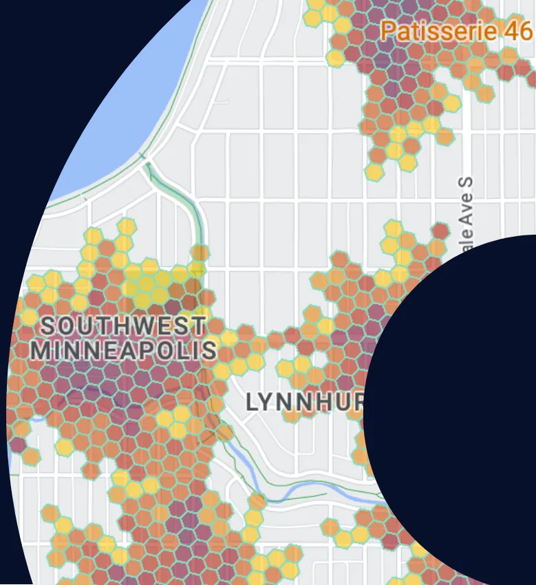 [Request a demo
](../request-live-demo/index.html)
IoT Analytics & Smart Cities
Why invest millions in IoT hardware if your IoT analytics isn’t up to scratch? Location Intelligence can enable Smart Cities to get an ROI from their sensor networks.
Request a demoTrusted by the world’s leading ORGANIZATIONS


Are you getting the spatial insights required from your IoT networks?
Companies & cities are investing millions in connected sensors, but achieving an ROI is dependent on setting up robust IoT analytics that process the location data generated into tangible insights.
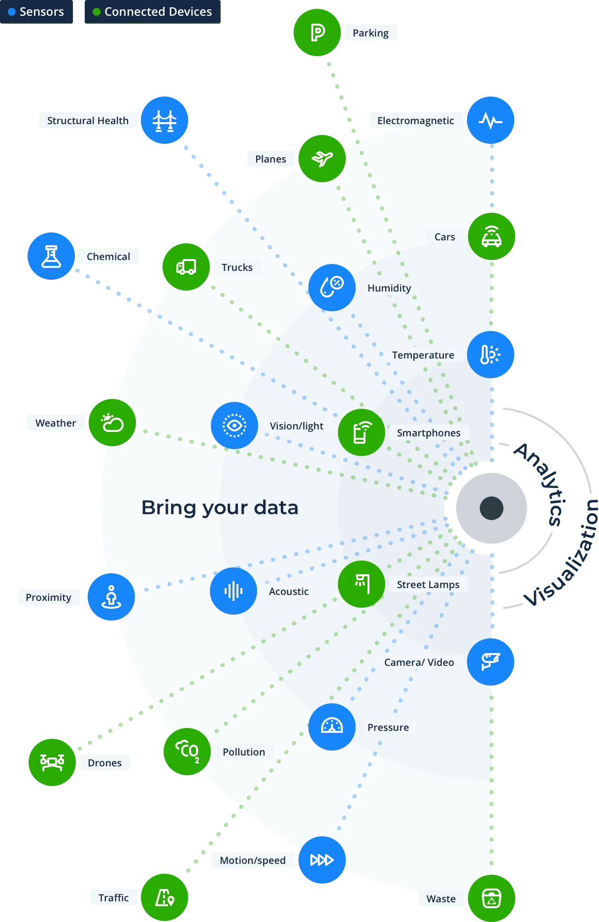

1. Connect your data
Connect to your lakehouse & enrich with sources from our Data Observatory.

2. Analytics
Analyze historic sensor-generated location data to inform future planning & resource allocation.

3. Visualization
Provide real-time, interactive dashboards to decision makers to help them reduce costs & build more efficient cities.
IoT Analytics Use Cases
Waste CollectionEnergy ManagementTraffic ManagementClimate InsightsAir Quality MonitoringElectric Vehicle ChargingSmart Health****Citizen Safety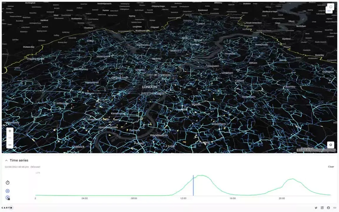

 Waste Collection: Reduce waste management costs using fill level sensors in trash cans across cities, allowing more efficient pick up routes & frequency.
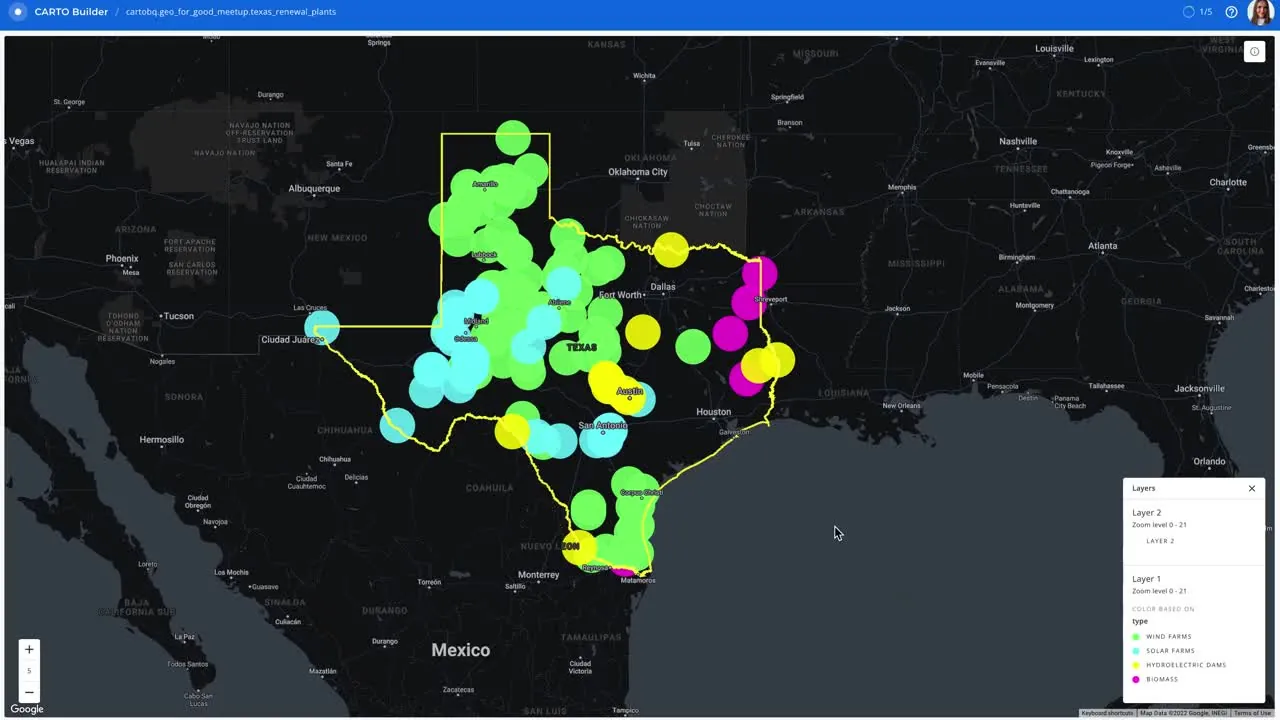 Energy Management: Reduce street lightning costs using spatial analytics to understand demand by time & location.
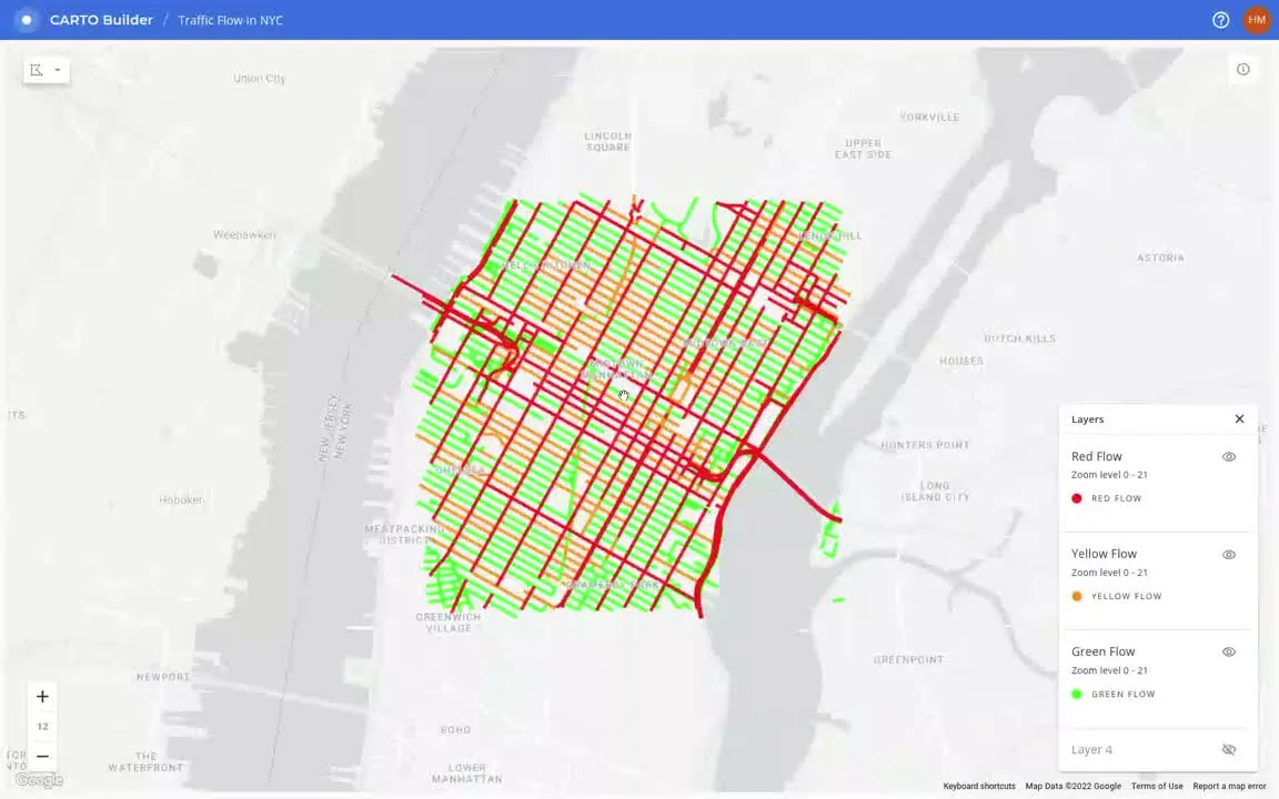 Traffic Management: Optimize public transport infrastructure, such as bikes, buses, trains, & metro services to reduce traffic & improve road safety.
-poster-00001.webp) Climate Insights: Climate Insights: Predict climate-related risks affecting the built environment, and drive more informed infrastructure decisions across government departments.
Climate Insights: Climate Insights: Predict climate-related risks affecting the built environment, and drive more informed infrastructure decisions across government departments.
-poster-00001.webp) Air Quality Monitoring: Monitor the emission of CO2 with pollution & temperature sensors to improve environmental management strategies & clean air planning.
Air Quality Monitoring: Monitor the emission of CO2 with pollution & temperature sensors to improve environmental management strategies & clean air planning.
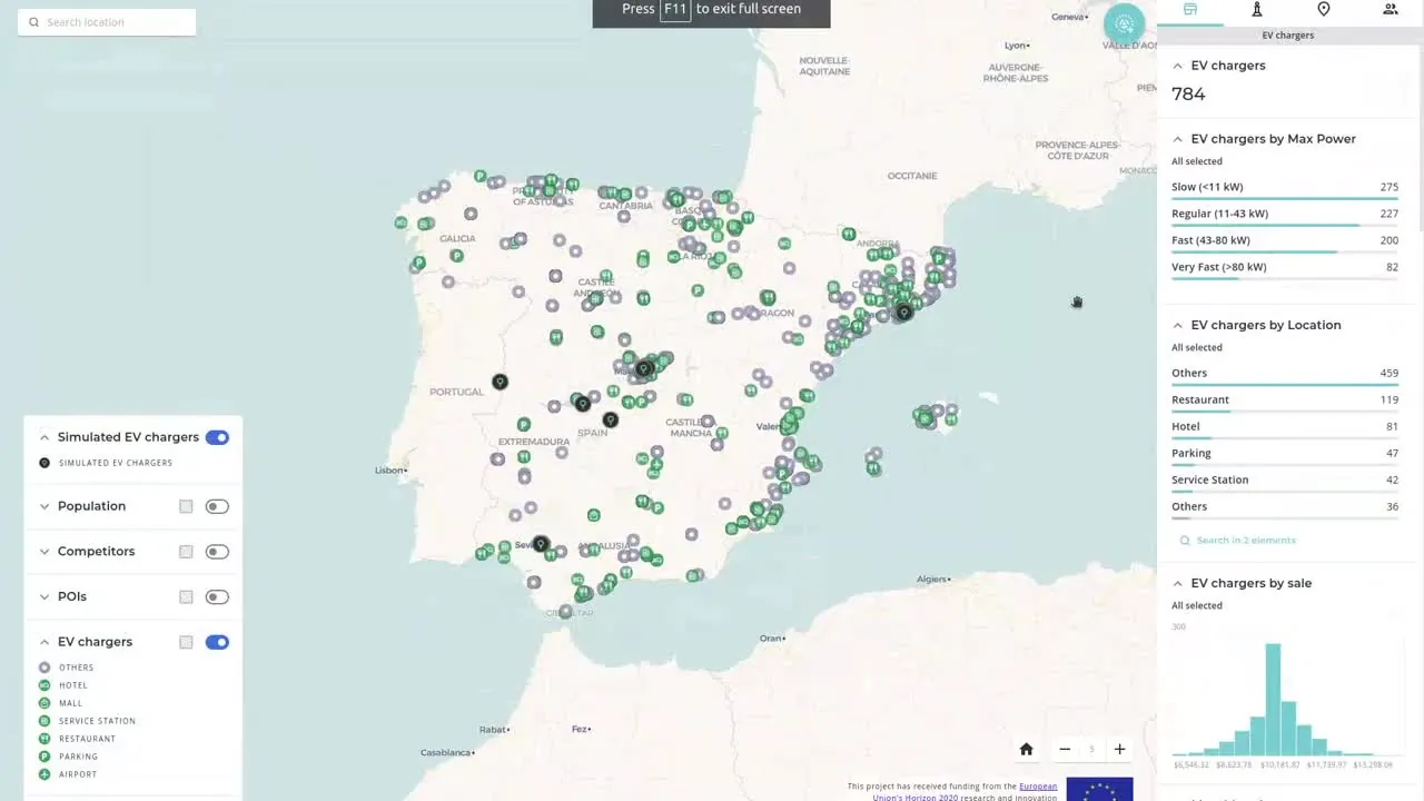 Electric Vehicle Charging: Identify prime locations for electric vehicle charging points based on demand, proximity & accessibility to key segments with a higher propensity to use or buy electric vehicles.
 Smart Health: Make critical decisions on resource allocation for public health services across your city, using Open Data alongside human mobility data.
 Citizen Safety: Identify higher risk locations across your city, predicting & analyzing crime data to ensure preventative measures are taken to improve citizen safety.
FEATURED STORIES
Get inspired by our customers

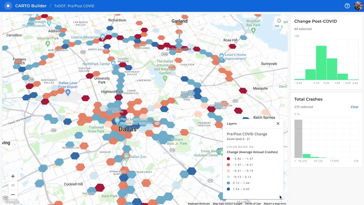
 ARUP Uses Spatial Analysis to Understand Road Accidents [Learn more
](https://carto.com/customer-stories/arup-spatial-analysis)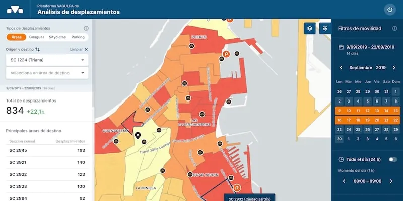Transport Analysis: SAGULPA Customer Story [Learn more
Transport](https://carto.com/customer-stories/arup-spatial-analysis)!%5B%5D(/cdn.prod.website-files.com/63483ad423421bd16e7a7ae7/63fb76ace521f20447cd01ff_sagulpa-platform-screenshot-1.webp)!%5B%5D(/cdn.prod.website-files.com/63483ad423421bd16e7a7ae7/63fb97a0284d878dd9263aee_sagulpa_logo.webp)Transport)
](../customer-stories/sagulpa-mobility-analysis.html)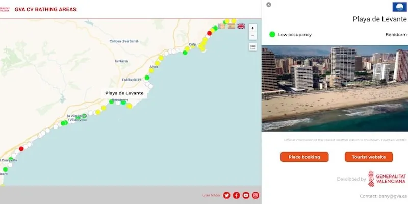
![]() Social Distancing: Generalitat Valenciana Customer Story [Learn more
Social Distancing: Generalitat Valenciana Customer Story [Learn more
](../customer-stories/generalitat-valenciana-social-distancing.html)
![]() United Nations: Geospatial Rapid Response [Learn more
United Nations: Geospatial Rapid Response [Learn more
](../customer-stories/unhcr-cities-governments.html)
Related content
.webp) ReportApplied AI for Spatial AnalyticsThis report walks through real examples, tools, and best practices to help you go from exploring AI to applying it in your spatial workflows.
[Download now
ReportApplied AI for Spatial AnalyticsThis report walks through real examples, tools, and best practices to help you go from exploring AI to applying it in your spatial workflows.
[Download now
](https://go.carto.com/report-applied-ai-for-spatial-analytics-real-examples-implementation-tips).webp)BlogLive maps with automated Workflows integrations are hereCreate live, always-updated maps with CARTO by integrating Workflows and Builder. [Read more
.webp)BlogLive](https://go.carto.com/report-applied-ai-for-spatial-analytics-real-examples-implementation-tips)!%5B%5D(/cdn.prod.website-files.com/63483ad423421bd16e7a7ae7/688b873aba8afe432c184982_Live%20maps%20with%20automated%20Workflows%20integrations%20are%20here%20(1).webp)BlogLive)
](https://carto.com/blog/live-maps-with-automated-workflows-integrations-are-here)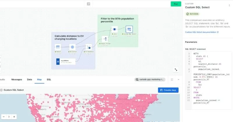BlogOptimizing Site Selection for EV Charging StationsHow to optimize EV Charging Site Selection with Spatial Data Science? Improve accessibility and convenience, drive revenue, and de-risk growth with this guide. [Read more
BlogOptimizing](https://carto.com/blog/live-maps-with-automated-workflows-integrations-are-here)!%5B%5D(/cdn.prod.website-files.com/63483ad423421bd16e7a7ae7/655ded7ad738eaf58b545317_Optimizing%20Site%20Selection%20for%20EV%20Charging%20Stations.webp)BlogOptimizing)
](https://carto.com/blog/ev-charging-stations-optimizing-site-selection)TALK TO US
Request a Demo
Schedule a 20 minute meeting with our experts to understand how you can use spatial analysis in your organization.
![]()
![]() Platform
Platform
- Overview - Visualization - Analytics - App Development - Data Enrichment - Security & Governance - Gen AI - Pricing - Solutions
- Data Analyst - Developer - Data Scientist - GIS Professional - By Industry - By Use Case - Resources
- Customer Stories - Blog - Glossary - Documentation - Academy - Reports - Events - Webinars - Partners - Company
- About us
- Newsroom
- Careers
- Brand
- Grants
Unlock the power of spatial analysis.


 © CARTO 2024
Terms
Privacy Notice
Whistleblower Form
© CARTO 2024
Terms
Privacy Notice
Whistleblower Form